Rahat- Integrated Relief & Disaster Management

Rahat- Integrated Relief & Disaster Management,
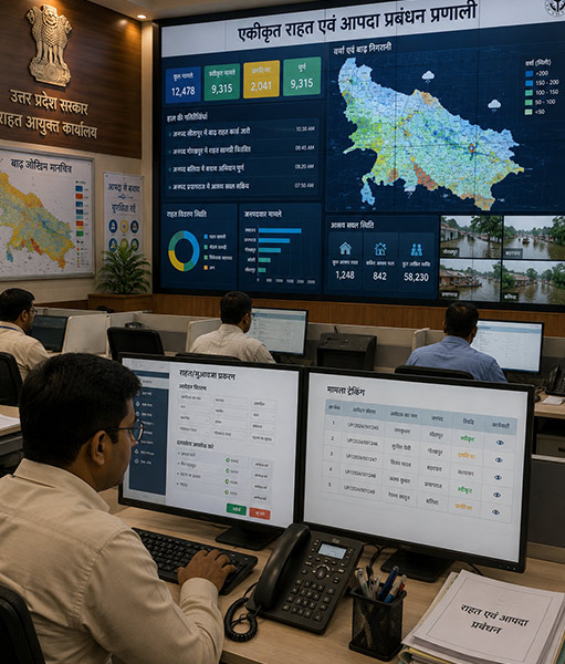
The Integrated Relief & Disaster Management Portal is a unified digital solution developed for the Office of the Relief Commissioner, Government of Uttar Pradesh, to streamline disaster compensation, relief logistics and emergency response operations across departments. The platform brings together relief assistance, beneficiary management, compensation processing,
flood-risk monitoring and disaster preparedness within a centralised digital ecosystem.
The system enables end-to-end digital processing of compensation and relief cases, from registration and verification to approval, fund transfer and beneficiary tracking. It integrates GIS-based flood-risk mapping, real-time monitoring, state, district and block-level dashboards, disaster response coordination and shelter management to support
faster, transparent and data-driven decision-making during emergencies.


Key Benefits
Faster Relief Delivery
Digitised workflows enable quicker processing and delivery of compensation and relief assistance.
Transparent Compensation Management
End-to-end tracking from registration to approval and fund transfer improves accountability and transparency.
Direct Beneficiary Support
DBT-based fund transfers enable relief assistance to reach eligible beneficiaries directly.
Real-Time Disaster Monitoring
Centralised dashboards provide timely visibility into disaster situations, relief operations and response activities.
GIS-Based Risk Assessment
Flood-risk mapping and location-based information support better preparedness and targeted intervention.
Multi-Level Coordination
State, district and block-level monitoring strengthens coordination between authorities and field teams.
Data-Driven Decision Making
Consolidated operational and beneficiary data enables authorities to assess situations and make informed decisions.
Improved Emergency Preparedness
Integrated shelter monitoring, disaster response and relief modules strengthen the state's overall disaster management capabilities.
Key Features

Integrated Relief Management
Centralised management of relief and disaster-response activities across departments.
Digital Compensation Processing
End-to-end processing of compensation cases from registration and verification to approval and payment.
DBT-Based Fund Transfer
Direct transfer of approved relief and compensation funds to beneficiaries.
Beneficiary Management
Digital registration, verification and tracking of beneficiaries receiving relief assistance.
GIS Flood-Risk Mapping
Location-based mapping and monitoring of flood-prone areas for improved preparedness and response.
Three-Tier Monitoring
State, district and block-level dashboards for coordinated disaster management and supervision.
Shelter Monitoring
Digital monitoring of relief shelters, including operational status and occupancy information.
Real-Time Disaster Response Dashboard
Centralised visibility of disaster situations, relief operations, field activities and response status.